Assam’s Dhola-Sadiya bridge or Bhupen Hazarika Setu- Why this bridge is an asset to the region
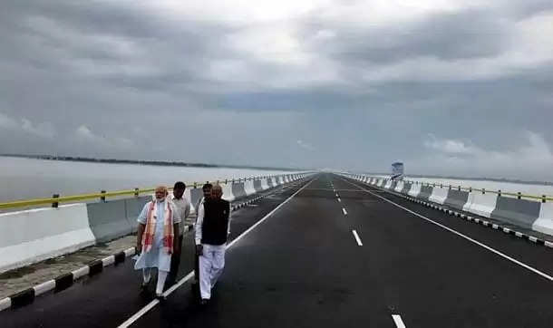
Two States had been impaired by this stretch of 9.15 km broad river Lohit, a tributary of Mighty Brahmaputra River, in both economic and defence-strategic grounds for so long years, and the good news is that this problem has come to an end. Before this construction, people would have to cross the river in order to reach the either ends of the valley by ferries and this had to be done only during the daytime, because nights were unsafe and often the river used to get flooded during the monsoon.
The cognizance of shortening the distance between the two places- Dhola in Assam and Sadia in lower-Arunachal Pradesh by 165 km, although came very late shall make a promising boost to the economical growth of both Assam and Arunachal Pradesh, as it shall cut short the hours of travel from six to just one.
Economically and rather environmentally, the involved researchers have calculated a saving of petrol and diesel worth Rs 10 lakh per day. With that, this will also enable the Indian Government to embark hydro-power projects in the near future.
For the concern to the Defence Ministry, whose anxiety always been lying with China at the North, this bridge will shorten the time-travel of the convoys and the logistics supplies to the soldiers posted in the Indo-China border.
STRATEGIC IMPORTANCE
For the Brahmaputra River after the Kaliabor bridge in Central Assam throughout the 376 km of the river bank, there is no bridge connecting the valleys separated by it. In the upstream after 120km there is a bridge available for crossing the river, but it travels through difficult hilly territory on the Northern-bank.
Since all the transportation had so far being carried through river-ferries only, now this bridge shall give the safest means for these commuters with savings of 4-5 hours per journey between the two valleys. The ferry travel would take about 4.5 hours while now the 9.15 kms long bridge would make it possible to run in just thirty-minutes.
So the likely population to be served would be 2,20,000 persons from both the states.
A BRIEF ABOUT THE CONSTRUCTION OF THIS BRIDGE:
#1. Construction was kicked off by the former UPA Government in January 2009 as part of the Arunachal Pradesh package of roads and highways, while the actual construction began in 2011.
#2. This project is a public-partnership (PPP) model undertaken by Ministry of Road Transport and Highways with Navayuga Engineering Company Limited of Hyderabad. The expert team was led by Mr. B Surya Raju, Chief-Project Manager and Mr. K. Jagadishwara Rao, Director of the company.
#3. The project was planned to be completed by 2015, but delayed to 2017. So it was inaugurated today in 26th May, 2017 by Hon'ble Prime Minister Shri Narendra D. Modi.
#4. Investment done was approximated to Rs. 2,056 crore.
#5. Total length= 9.15 kms and total width = 12.9m having 182 piers of 50m, each
So the entire people of North-East India is grateful to every individual who was directly or indirectly involved in making the construction successful. The engineers, lead designers, and investors have done an implausible job in working through the years in creating the safe bridge that can withstand high seismic earthquakes.
We are also grateful to the Government and the private Partner Navayuga Engineering Company Limited of Hyderabad to make it all possible.
I hope that in the coming future both the citizens of the place and the Governments shall put their efforts to maintain the bridge.
(by Sidhanth Majumder)
The author can be contacted at sidhanthm.123
The views reflected in this piece are that of the author and need not necessarily be that of TNT-The Northeast Today
Featured image(courtesy): India.com