Super Cyclone Amphan likely to hit Bengal, here’s all you need to know
FACTS | MAY 19, 2020:
Cyclone "Amphan", rightly pronounced as "Um-pun", means sky. The name was given by Thailand in 2004. According to the Press Information Bureau, the next few cyclones will be named Nisarga (suggested by Bangladesh), Gati (India), Nivar (Iran), Burevi (Maldives), Tauktae (Myanmar) and Yaas (Oman).
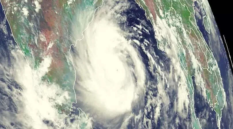
Amphan is the equivalent of a Category-5 hurricane on the Saffir-Simpson Hurricane Wind Scale, according to US space agency NASA. The space agency's Aqua satellite passed over the Indian Ocean on Monday and gathered water vapor data that showed the intensity of powerful tropical cyclone.
NASA utilized the images to gather data about the temperature of the cloud top, which is the highest altitude of the visible portion of the cloud. "Coldest cloud top temperatures were as cold as or colder than minus 70 degrees Fahrenheit (minus 56.6 degrees Celsius) in those storms. Storms with cloud top temperatures that cold have the ability to produce heavy rainfall," NASA said in a blog.
The storm was formed over south-east Bay of Bengal on 16th May. "It was designated Tropical Cyclone 01B. Overnight, it quickly strengthened to hurricane force," NASA said.This is the second pre-monsoon cyclone to form in the Bay of Bengal in the last two years. Odisha, which was praised for its handling of pre-monsoon storm – Cyclone Fani – last year.
Cyclone Amphan is expected to hit Bengal tomorrow (20th May) with maximum sustained wind speed of 155-165 km per hour, gusting to 185 km per hour. It is likely to make a landfall as a strong storm equivalent to a Category 3 hurricane.
The storm is expected to bring strong winds, storm surge and flooding to coastal areas of West Bengal in India and Bangladesh. The Indian space agency has warned of a storm surge of about 4-5 meters above astronomical tide that is likely to flood low-lying areas of West Bengal during landfall.
Massive destruction is expected since the coastal areas that will be struck are densely populated. The IMD anticipates extensive damage to houses and potential threat from flying objects. Rail and road traffic will also be disrupted.
Doppler Weather Radar at Vishakhapatnam has been constantly tracking the storm.
Light to moderate rainfall has been predicted in Sikkim, Assam and Meghalaya, which may also be impacted by the storm.